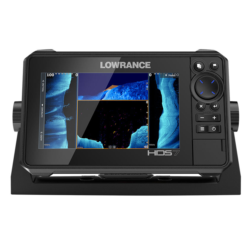
LOWRANCE ECO/GPS HDS 7 LIVE

Refference :
5605326
DISPLAY 7" WITH TRANSDUCER ACTIVE IMAGING 3-1
Description
Full HD multi-touch screen SolarMAX ? - Offers high-resolution images that can be easily viewed from multiple angles.StructureScan? 3D - Allows a view of the structure and the marine profile in a three-dimensional perspective. 3D images analyze theunderwater terrain and structure in order to create a high-resolution 180-degree and three-dimensional view of the bottom under the boat.Active Imaging ? - Together with the new CHIRP / SideScan / DownScan Active Imaging ? 3-in-1 Transducer you get a level of detail and image qualityleader in the industry. Excellent performance with coverage never before achieved by other sonar imaging technologies. New simultaneous view of the various bars activeimaging. 3D representation.FishReveal ? - Allows a level of sharpness of the markings unmatched. Simple to use the 800 kHz setting provides crystal clear imagesultra-detailed without compromising the range. For a view of more than 36 meters Active Imaging can also work at 455 kHz up to about 60 meters.LiveSight ? Real-time compatible sonar - With the dedicated LiveSight transducer mounted in the bow the Livesight Foward view allows you to detect the mostminimum movement of the fish and observe the reaction of the fish in the presence of the bait or how they relate to what they have around them. Used togetherto the Lowrance GPS Point-1 antenna an innovative indicator will show directly on the map the direction to which the transducer is pointing allowingto the fishermen to align themselves with a waypoint or to locate the structure where to throw the bait. Mounting the transducer towards the bottom and activating the LiveSight viewDown we get a real-time view under the hull ideal for "vertical jigging" "drop shot" fishermen. LIVE SMARTPHONE INTEGRATION (only on the HDS 12 ") - Offers the possibility to enjoy the entertainment content present on your smartphone directly on the HDS while the mobile phone is stored in a safe place. The contents can be viewed in full screen or on portions viaHDMI and USB connection offering the ability to play streaming video view Google maps and fishing data.C-MAP Genesis Live - An incredibly intuitive and real-time cartographic experience. Users can control transparency and density of thecontours on the screen up to intervals of 15cm as well as customize the colors of the bathymetric and much more. Maps can beSave quickly and easily on an SD card for continuous use.Autorouting and Easy Routing from pier to dock - Suggest new locations of route points based on map information and sizeof the boat. In order to start using this feature you must enter the draft width and height of the boat in the system. If they are notinformation is available when the function is started the Boat Settings window will automatically be displayed. Navionics cartography requiredPlatinum and a subscription to Navionics or the CMAP MAX-N + cartography (It must not replace the normal procedures for safe browsing and must notbe the only source of reference.)Dual-Channel CHIRP - Double Chirp channel allows the use of two Chirp transducers with differrent Bands or installed in different positions.Wireless and Bluetooth? connectivity - For connection to WI-FI hotspots and compatible mobile phones. Bluetooth offers greater integration withMobile Devices Allowing you to view messages and calls received on your device.Radar and SonicHub?2 audio server - Integrates with Halo24 and Broadband Radars. Manages on-board entertainment via the SonicHub.Integration with engines - With the introduction of Yamaha engine data on the HDS Carbon and Gen3 displays with software 18.1 the new version 18.2 allowsthe monitoring of the Mercury Suzuki Yamaha and Evinrude compatible engines connected in Nmea2000.
Units Of Measure

1,738.80

DISPLAY 7″ WITH TRANSDUCER ACTIVE IMAGING 3-1

SKU: 5605326

Description

Full HD multi-touch screen SolarMAX ? – Offers high-resolution images that can be easily viewed from multiple angles.StructureScan? 3D – Allows a view of the structure and the marine profile in a three-dimensional perspective. 3D images analyze theunderwater terrain and structure in order to create a high-resolution 180-degree and three-dimensional view of the bottom under the boat.Active Imaging ? – Together with the new CHIRP / SideScan / DownScan Active Imaging ? 3-in-1 Transducer you get a level of detail and image qualityleader in the industry. Excellent performance with coverage never before achieved by other sonar imaging technologies. New simultaneous view of the various bars activeimaging. 3D representation.FishReveal ? – Allows a level of sharpness of the markings unmatched. Simple to use the 800 kHz setting provides crystal clear imagesultra-detailed without compromising the range. For a view of more than 36 meters Active Imaging can also work at 455 kHz up to about 60 meters.LiveSight ? Real-time compatible sonar – With the dedicated LiveSight transducer mounted in the bow the Livesight Foward view allows you to detect the mostminimum movement of the fish and observe the reaction of the fish in the presence of the bait or how they relate to what they have around them. Used togetherto the Lowrance GPS Point-1 antenna an innovative indicator will show directly on the map the direction to which the transducer is pointing allowingto the fishermen to align themselves with a waypoint or to locate the structure where to throw the bait. Mounting the transducer towards the bottom and activating the LiveSight viewDown we get a real-time view under the hull ideal for “vertical jigging” “drop shot” fishermen. LIVE SMARTPHONE INTEGRATION (only on the HDS 12 “) – Offers the possibility to enjoy the entertainment content present on your smartphone directly on the HDS while the mobile phone is stored in a safe place. The contents can be viewed in full screen or on portions viaHDMI and USB connection offering the ability to play streaming video view Google maps and fishing data.C-MAP Genesis Live – An incredibly intuitive and real-time cartographic experience. Users can control transparency and density of thecontours on the screen up to intervals of 15cm as well as customize the colors of the bathymetric and much more. Maps can beSave quickly and easily on an SD card for continuous use.Autorouting and Easy Routing from pier to dock – Suggest new locations of route points based on map information and sizeof the boat. In order to start using this feature you must enter the draft width and height of the boat in the system. If they are notinformation is available when the function is started the Boat Settings window will automatically be displayed. Navionics cartography requiredPlatinum and a subscription to Navionics or the CMAP MAX-N + cartography (It must not replace the normal procedures for safe browsing and must notbe the only source of reference.)Dual-Channel CHIRP – Double Chirp channel allows the use of two Chirp transducers with differrent Bands or installed in different positions.Wireless and Bluetooth? connectivity – For connection to WI-FI hotspots and compatible mobile phones. Bluetooth offers greater integration withMobile Devices Allowing you to view messages and calls received on your device.Radar and SonicHub?2 audio server – Integrates with Halo24 and Broadband Radars. Manages on-board entertainment via the SonicHub.Integration with engines – With the introduction of Yamaha engine data on the HDS Carbon and Gen3 displays with software 18.1 the new version 18.2 allowsthe monitoring of the Mercury Suzuki Yamaha and Evinrude compatible engines connected in Nmea2000.

Reviews

There are no reviews yet.

Be the first to review “LOWRANCE ECO/GPS HDS 7 LIVE”

Your email address will not be published. Required fields are marked *

Code Product Qty Price
5605326 DISPLAY 7" WITH TRANSDUCER ACTIVE IMAGING 3-1
€1738.8

7 other Products In The Same Category: